

Myriad Uranium Corp
CSE:MLive AI agent
Myriad Uranium Corp.
Investor website: https://myriaduranium.com/
About
Myriad Uranium Corp. (CSE: M) (OTCQB: MYRUF) (FSE: C3Q) is focused on unlocking strategic uranium deposits for the U.S. supply chain, targeting over 100 million pounds of uranium in Wyoming, New Mexico, and Arizona. The company aims to increase domestic uranium production to support U.S. energy security and reduce dependency on foreign sources.
Verified company data
- Shares outstanding
- 105,215,748
- Fully diluted shares
- 161,129,800
- Mineral resource
- Myriad Uranium holds a 75% earnable interest in the Copper Mountain Uranium Project which saw US$78m (2024$) in exploration and development expenditures by Union Pacific during the 1970s. Union Pacific drilled approximately 2,000 boreholes, discovered 7 uranium deposits, and developed a 6-pit mine plan at Copper Mountain, estimating resources of between 15.7 and 30.1 Mlbs eU3O8 and estimating the further potential of known and speculated targets within the project area to be over 65 Mlbs. These estimates are historical and not yet current under NI 43-101. Myriad Uranium intends to bring these historical estimates current under NI 43-101 and if possible, go beyond them, initially focusing on the ‘High Grade Zone’ of the Canning Deposit (see Figure 1), which hosts the largest estimated historical resources at Copper Mountain.
- Projects
- ["## Copper Mountain, Wyoming, USA\n\n### Latest News\n\n[SEE LATEST NEWS](https://myriaduranium.com/news/)\n\n### Project Presentation\n\n[DOWNLOAD PRESENTATION](https://myriaduranium.com/wp-content/uploads/2026/09/myriad-uranium-corporate-presentation-october-2026-compressed.pdf)\n\n### Technical Report\n\n[DOWNLOAD REPORT](https://myriaduranium.com/wp-content/uploads/2026/04/copper-mountain-ni43-101-technical-report_signed_202600417.pdf)\n\n## THE COPPER MOUNTAIN URANIUM PROJECT\n\n\n\n#### Located in America’s leading uranium jursdiction\n\n- Wyoming hosts the largest-known uranium ore reserves in the United States.\n- The state accounts for 69% of U.S. production from 5 operating mines.\n\n#### TIER-ONE JURISDICTION WITH EXCELLENT ACCESS TO INFRASTRUCTURE\n\n#### One of the largest uranium projects in Wyoming.\n\n- **100%-owned, 18,000+ acre land package with 7 historic deposits, 11 prospects with historic drilling, 10 additional targets with no historic drilling.**\n- This is the **first time ownership of Copper Mountain has been consolidated in almost 50 years.**\n- Comprehensive U.S. Dept. of Energy report (Bendix, 1982) estimated an Exploration Target* of **1,111 to 2,971 Mt** at 100 ppm eU3O8 or **222 to 594 Mt** at 500 ppm eU3O8 potentially containing between **245 Mlbs** (Control Area – 80% held) and **655 Mlbs** (Assessment Area – 62% held).\n- Access to infrastructure – **the project is located within 5 km of regional rail, highway, and power lines.**\n\n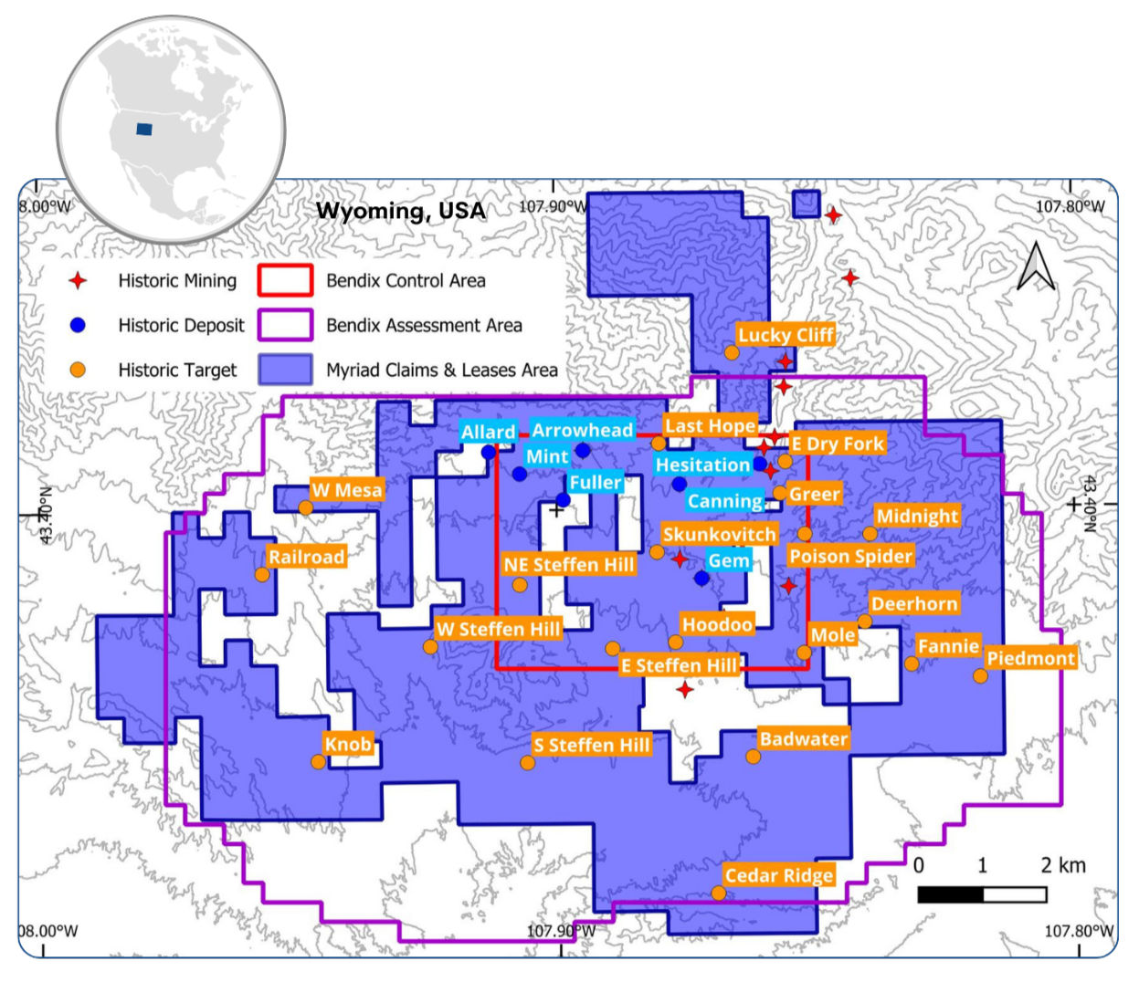\n\n###### *The potential quantity and grade is conceptual in nature. There has been insufficient exploration to define a mineral resource and it is uncertain if further exploration will result in the target being delineated as a mineral resource.\n\n###### * This estimate is historical in nature and does not represent current mineral resource, reserve or exploration target estimates under the category definitions provided by NI 43-101. It represents potential a mineral endowment that would require exploration work and drilling to verify. The key assumptions, parameters, and methods used to prepare the historical estimates are described in this document. There are no more recent estimates of this type. A qualified person has not done sufficient work to classify the historical estimate as current mineral resources or mineral reserves. Myriad and Rush are not treating the historical estimate as current mineral resources or mineral reserves. Also, while the Copper Mountain Project area contains all or most of each deposit referred to, some of the resources referred to may be located outside the current Copper Mountain Project area.\n\n#### COPPER MOUNTAIN, WYOMING\n\n#### LOOKING NORTH AT COPPER MOUNTAIN\n\n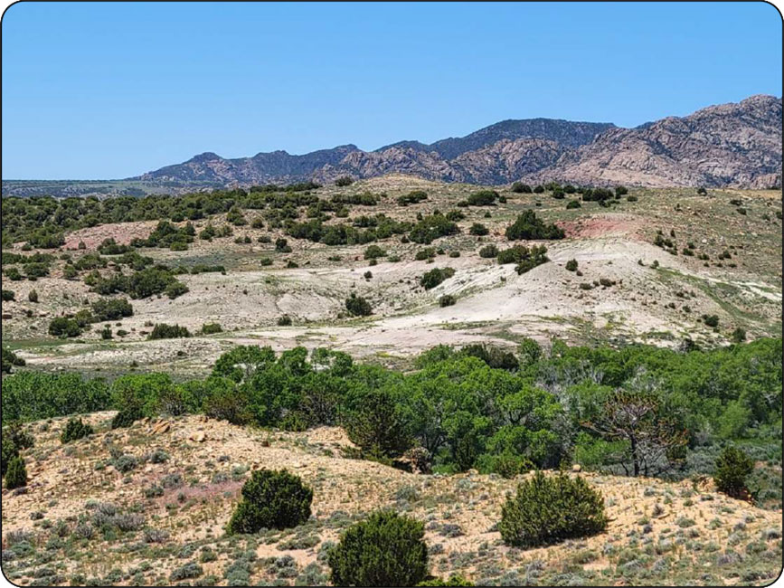\n\n#### LOOKING SOUTH FROM THE CANNING DEPOSIT\n\n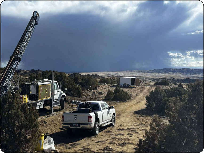\n\n#### COMPELLING GEOLOGY INCLUDING ISR POTENTIAL AT COPPER MTN.\n\n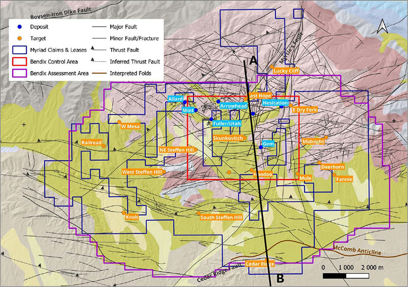\n\n#### Multiple Deposit Types\n\n- Historic drilling mainly targeted granite-related mineralization down to 600 feet (e.g. North Canning).\n- But there is associated sedimentary mineralization (e.g. Arrowhead).\n- And the possibility of roll-front mineralization in Tertiary sediments (e.g. Cedar Ridge).\n- And also the possibility of deeper thrust/unconformityrelated mineralization (e.g. Railroad).\n\n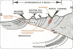\n\n#### RESOURCE EXPANSION\n\n#### Historic work provides a launchpad for rapid project advancement.\n\n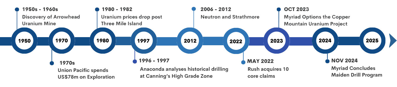\n\n### 1950s-1960s\n\nLegendary geologist and Myriad technical advisor Jim Davis discovers the Arrowhead Mine which, according to publicly available production records (United States Department of the Interior), produced ~500 klbs of uranium in the 1950’s and 1960’s.\n\n### 1970s\n\n**Union Pacific** drilled 2,000 boreholes discovering 7 deposits during the 70’s.\n\n- They envisioned a conventional hub & spoke, 6-pit mine plan centered on the Canning deposit.\n- They had designed a leach pad and had plans to commence mining in 1983, but dropped those plans in ~1980 after prices plummeted following Three Mile Island incident.\n- Union Pacific estimated the potential of the 6-pit mine plan and additional targets (estimated and speculated) to be far higher.\n\n**Anaconda Copper** drilled 19 boreholes into the Railroad Target area adjacent to Union Pacific’s Copper Mountain project.\n\n- Intersected elevated mineralization at depth. Crucially tested for deeper mineralization associated with thrust faults.\n\n### 1990s\n\n**Anaconda Uranium** (no relation to Anaconda Copper) acquired all the historical data in the early 90’s and spent several years analyzing the data.\n\n- They focused on an “Area of interest” at the Canning deposit.\n- Two review reports (1991 and 1997) confirmed that Copper Mountain has substantial uranium mineralization with heap leach potential, and possibly an ISR option (not tested).\n- Both recommended bulk sampling and testing as part of further work.\n\n### 2006-2012\n\n**Neutron Energy & Strathmore** both held parts of the Copper Mtn Project. Their ownership had divided Canning Deposit and most of the entire district.\n\n**Neutron Energy** brought back geologist Jim Davis and re-evaluated all the historical data which was summarized in a 2008 technical report.\n\n- Suggested the equivalent uranium grades used in the histori estimation were conservative and noted that fluorometric analyses suggested higher grades but were disregarded (Davis & Wilton, 2010).\n- Myriad’s Phase I drilling results support this. Recommended various programs targeting several styles of mineralization.\n\n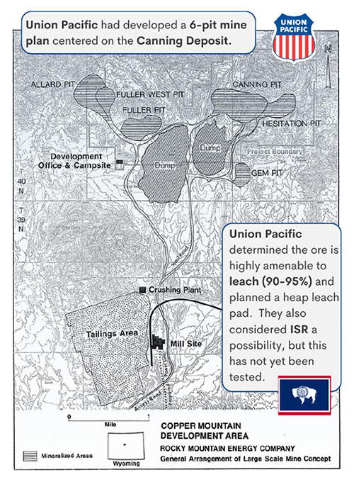\n\n#### PHASE I DRILL PROGRAM - CONFIRMED HISTORICAL RESULTS AT CANNING\n\n#### Historical Drilling\n\n- ~820 holes were drilled in the Canning deposit by Union Pacific, generally to a maximum depths of around 180 m.\n- Contains bulk of historic mineralization identified by Union Pacific.\n- Priority area contains higher average grades than the overall mineralized area.\n\n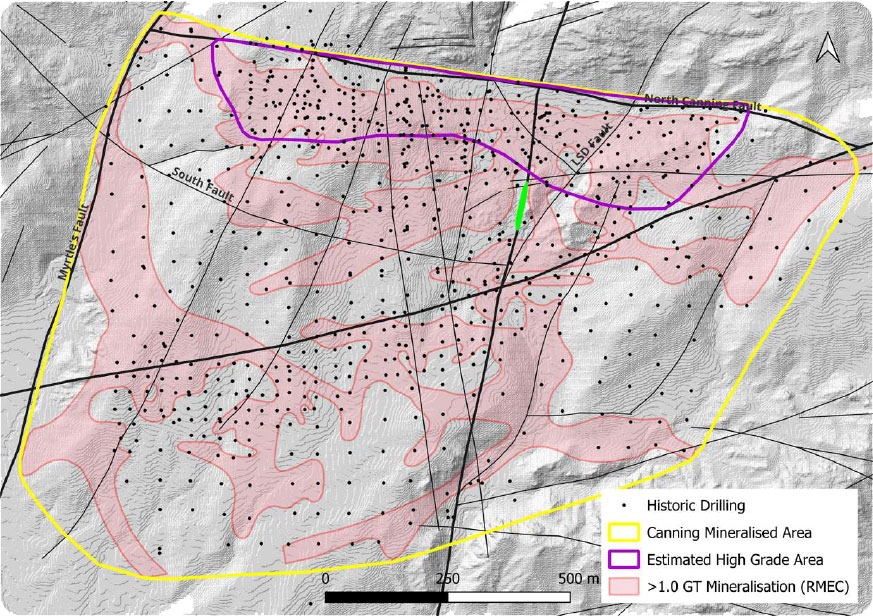\n\n#### Myriad’s Phase I Drilling – November, 2025\n\n- Focused on the priority target area, known to contain higher grades.\n- 34 holes completed (RC and DD).\n- Best grade interval: 5,337 ppm over 1.28 m from 68.7 m (CAN0004).\n- Best GT interval: 4,361 ppm over 2.29 m from 80.9 m (CAN0006).\n\n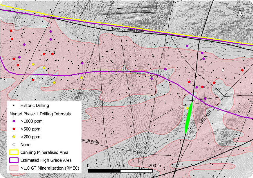\n\n#### Fault Mineralising Model\n\n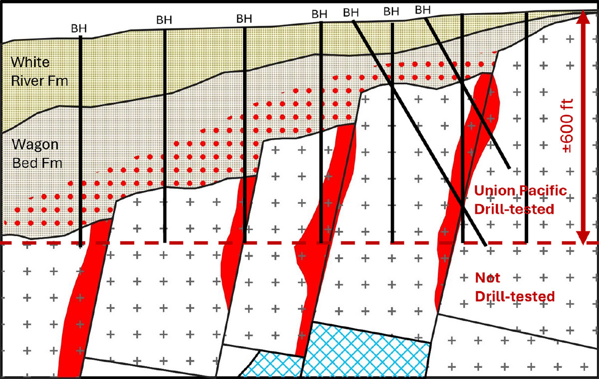\n\nModified after Carter (2008) - Not to scale\n\n#### Copper Mtn Uranium Project – Core Shed: Riverton, WY\n\n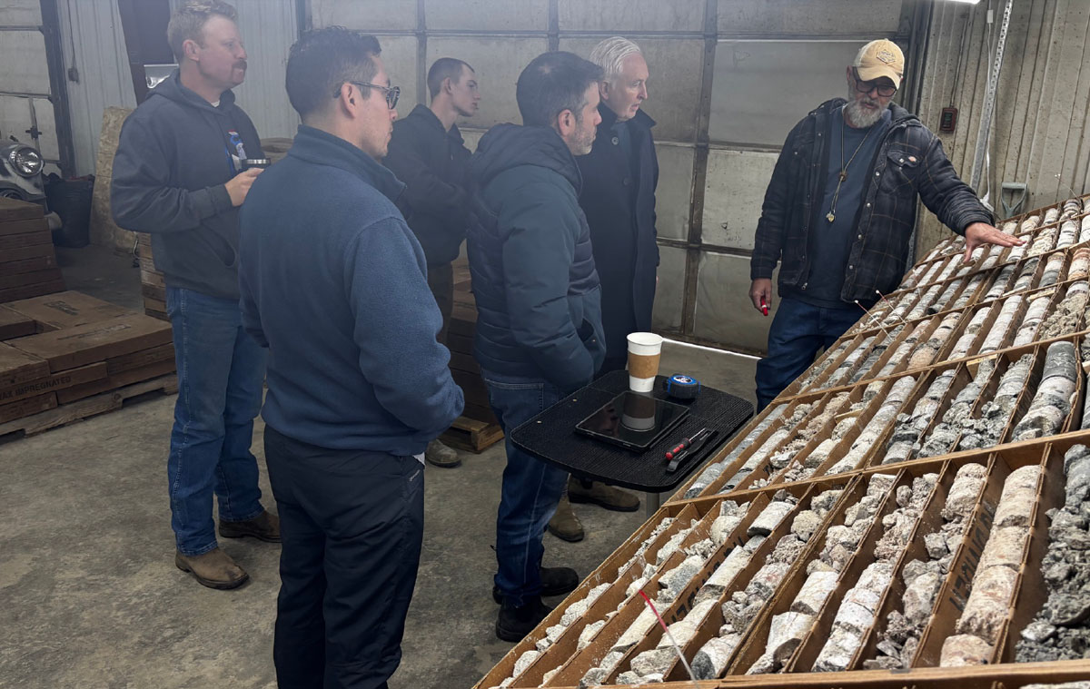\n\n#### ASSAYS\n\n#### In the 1970s, Union Pacific only relied on probe data to estimate resources and plan the mine.\n\n- Union Pacific relied on DFN probe data, which was considered conservative.\n- 1970s fluorometric assays indicated that DFN probe could be underestimating grades, but the results were disregarded in favor of DFN probe data.\n- Reported ICP-MS assay results show chemical grades superior to spectral gamma probe equivalents, and gaps may also contain significant unreported uranium mineralization.\n\n#### Assays across the 34 boreholes to date show the following relative to probe equivalent results:\n\n- Assay grades 60% higher than eU O at 3 8 1,000 ppm cut-off.\n- Assay grades 50% higher than eU3O8 at 500 ppm cut-off.\n- Assay grades 20% higher than eU3O8 at 200 ppm cut-off.\n- CAN0034 had a >250% improvement in grade from 344 ppm eU3O8 to 833 ppm U3O8 over 0.5 m at 454 m depth.\n\n## REVEALED HIGHER GRADES AND DEEPER MINERALIZATION\n\n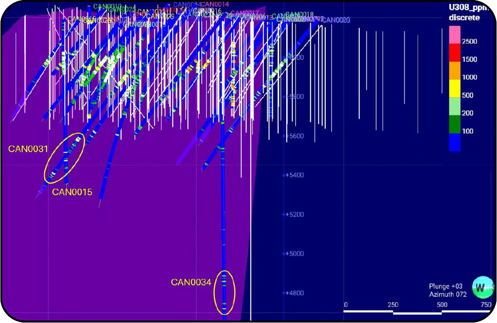\n\n#### PHASE I DRILL PROGRAM\n\n## SHOWING CONTINUITY IN THE CANNING “AREA OF INTEREST”\n\n#### Phase 1 Drilling Increases Confidence in Resource\n\n- Phase 1 drilling confirmed mineralization modelled from historic drilling data.\n- Assay grades on average 20% – 60% higher than gamma probe grades.\n- **Myriad’s assays have increased shell volume versus previous gamma probe equivalent grades by 15%.**\n\n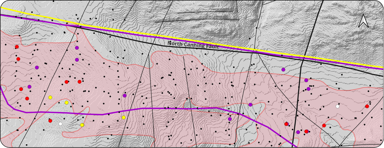\n\n### Mineralization Model Comparison\n\n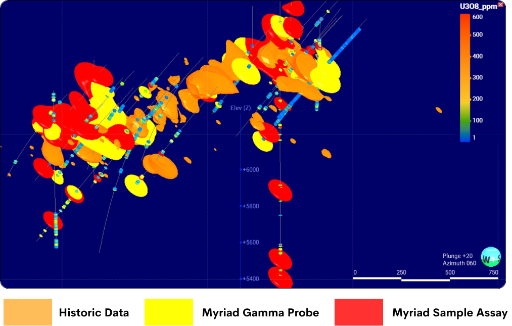\n\n#### HIGH-RES GEOPHYSICS ACROSS DISTRICT\n\n## NEW AREA CONTAINS VAST MAJORITY OF ANOMALY POINTS\n\n\n\n#### Magnetic and Radiometric surveys highlight significant potential to the east of known resources\n\n- 2,114 line-km magnetic and radiometric surveys completed (100 m line spacing, 30 m flying height).\n- Coincident magnetic and radiometric anomalies with structures establish mineralisation controls.\n- Confirms large extent of mineralisation potential. 140 radiometric anomaly points identified for follow-up investigation.\n- Known historic resources are located west of major NS structure – eastern extent remains untested.\n\n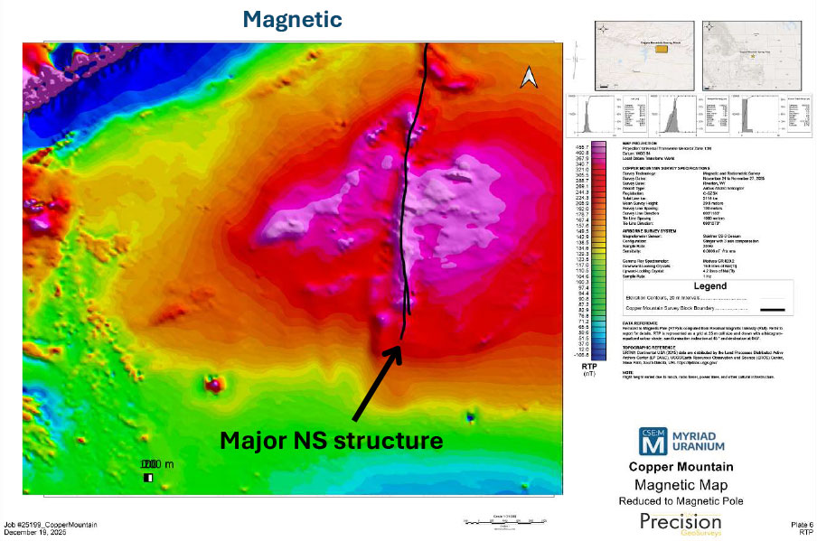\n\n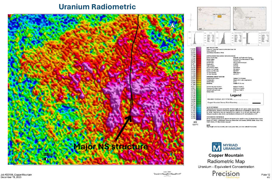\n\n#### FIELD WORK\n\n## GROUND-TRUTHING RADIOMETRIC ANOMALIES\n\n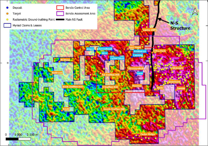\n\n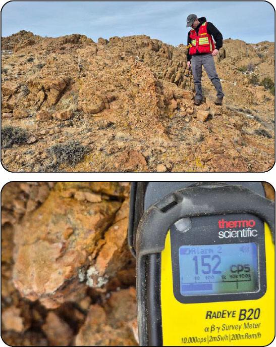\n\n#### Targets\n\n- Many new targets identified by radiometrics need to be followed up in the field.\n- Midnight alone has 60 plus points identified by recent geophysics for follow up.\n\n#### Confirm & Follow Up\n\n- Secondary uranium in granite outcrop near Midnight measuring over 100 times above background – confirms targeting.\n- Next step: detailed ground-truthing with sampling, followed by drilling.\n\n#### PHASE II DRILL PROGRAM\n\n## UNLOCKING COPPER MOUNTAIN’S POTENTIAL\n\n#### GRANITE HOSTED URANIUM\n\n- The seven-deposit historical resource of 26.63 Mlbs mainly hosted in granite – drilled toa depth of ~180 m.\n- The Bendix report defined many targets with granite endowment.\n- **Our geophysics identified radiometric anomaly areas where ground truthing has confirmed near-surface mineralization.**\n\n#### SEDIMENTARY HOSTED URANIUM\n\n- Sedimentary hosted uranium was mined at the Arrowhead deposit in the 1950’s.\n- Union Pacific identified potential rollfront mineralization at Cedar Ridge that could be ammenable to ISR.\n- The Bendix report defined targets with Sedimentary endowment.\n\n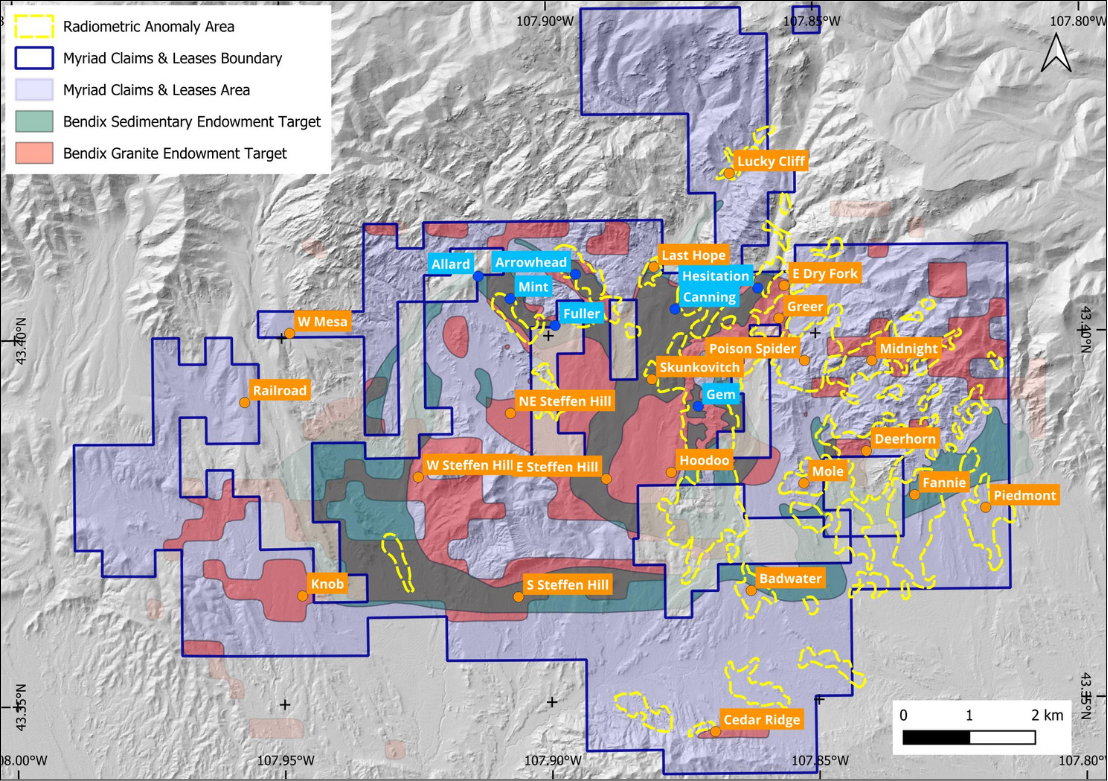\n\n#### PHASE II DRILL PROGRAM\n\n## DEFINE PATH TO RESOURCE AND UNLOCK DISTRICT POTENTIAL\n\n#### Myriad’s Phase II Drill Program – Currently Underway\n\n- Phase II will commence with a two-stage drill program totaling approximately 5,000 metres.\n- Current cash on hand will allow Myriad to rapidly advance beyond the initial two stages of the Phase II program.\n\n#### STAGE 1\n\n**OBJECTIVE: DEFINE A PATH TO RESOURCES**\n\n- Verify mineralization that underpins the historical estimate of 26.63 Mlb eU3O8 and generate modern data to support a future maiden mineral resource estimate*.\n\n###### *Subject to completion of sufficient exploration, QAQC, assay verification, geological modelling and estimation work by a Qualified Person.\n\n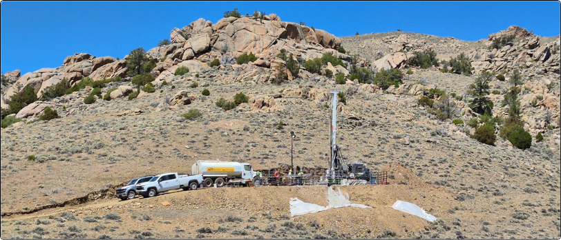\n\n#### STAGE 2\n\n**OBJECTIVE: UNLOCK DISTRICT POTENTIAL**\n\n- Evaluate exploration upside by testing **historical targets** identified through drilling in the 1970s, while also assessing **Myriad-driven targets.**\n\n#### PHASE II DRILL PROGRAM - STAGE 1\n\n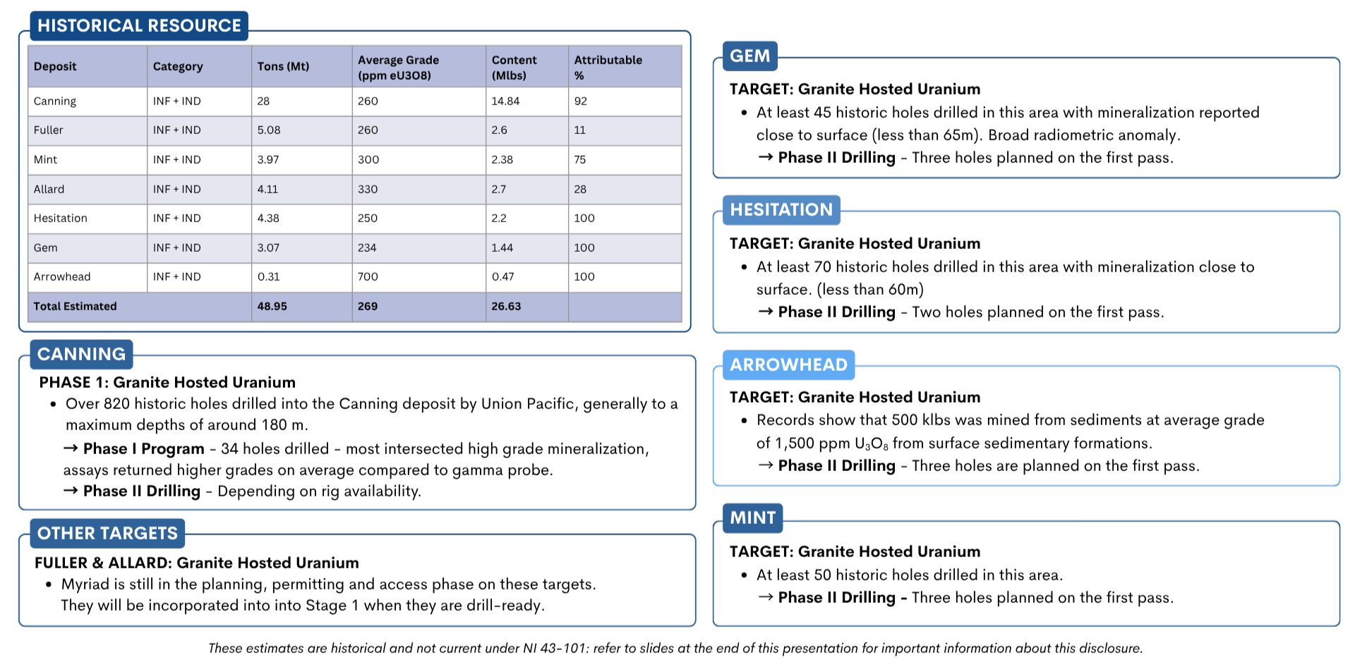\n\n#### PHASE II DRILL PROGRAM - STAGE 2\n\n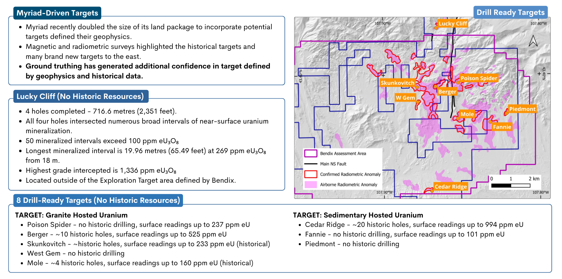\n\n#### COPPER MOUNTAIN PROGRESS\n\n#### Consolidate and Acquire the Copper Mountain Project\n\n- Myriad earned a 100% interest in Copper Mountain by spending over $5.5 million on eligible expenditures under the property option agreement under with Rush Rare Metals.\n- Myriad has almost doubled its land position to include the historically-defined deposits and targets in the district.\n\n#### Acquire Historic Data\n\n- Acquire data relating to the US$86 million in historic spend (2024$) at the project.\n\n“ [Myriad Transformed as Data Trove Reveals Significant Historical Uranium Resources at Copper Mountain](https://myriaduranium.com/myriad-transformed-as-data-trove-reveals-significant-historical-uranium-resources-at-copper-mountain/)” – Oct 2023 news release.\n\n#### Commence Myriad’s Maiden Drill Program\n\n- Confirm historically reported mineralization with Fall 2024 maiden drill program.\n- Focus on the Canning deposit which was the cornerstone of Union Pacific’s 6-pit mine plan.\n\n#### Next Steps\n\n- Report upcoming chemical assays from gap sampling; assimilate new uranium endowment estimates from Bendix (up to 656 Mlbs*).\n- Drill at other targets around Copper Mountain to confirm the broader potential of the district.\n- Continue testing deeper zones below historical 175m general maximum depth of drilling.\n\n###### *Not current under NI 43-101: For more information about historic resources and current exploration results, refer to the slides at the end of this presentation\n\n#### NOTES TO DISCLOSURE OF HISTORICAL ESTIMATES\n\n##### (AS PER SECTION 2.4 OF THE NI 43-101 STANDARDS OF DISCLOSURE FOR MINERAL PROJECTS)\n\n#### Copper Mountain, Wyoming\n\n###### a) The estimates completed by Fluor Mining and Metals Inc. (Fluor), May 20, 1980 are cited in several reports post-dating the estimate, including the most recent reference in a NI 43-101 Technical Report by Carter, G.S. (August 20, 2008) titled “Technical Report on the Uranium Resources at The Copper Mountain Project, Fremont County, Wyoming, U.S.A., on behalf of Neutron Energy Inc.” issued by Broad Oak Associates. The estimates for the Gem deposit and past-producing Arrowhead uranium mine deposits were completed by Rocky Mountain Energy Corp. in 1977 and cited in report titled “Copper Mountain Exploration Project Report by Southard, G.G., Morton, D.K., Gordon. J.H. and Schledewitz, D.C., RMEC (December 1979).\n\n###### b) The historical estimates are based on data and reports prepared by previous operators. This included data from over 900,000 feet of hammer tool and core drilling. The descriptions of core drilling and core handling procedures, sample preparation and analysis, and procedures for statistical correlation of various assay methods are all presented in the reports and are considered appropriate. Based on the amount and quality of historic work completed, the information is considered relevant and reliable. This view is supported by earlier reviewers of the data and methodology, including David S. Robertson & Associates Inc. (1978) and Golder Associates (1979), who concluded that the core and sample handling techniques from the field through the sample preparation facility were in “accordance with good engineering practice”. However, the resultant gamma logs and core assays that supported the estimations and associated technical work were not available to the Qualified Person, therefore a complete and thorough review of the data has not been possible.\n\n###### c) Earlier estimates by Rocky Mountain Energy Corp. (1977) used the polygonal estimation method based on ten-foot composite thicknesses and 0.010% U 0 cut-off using gamma probe grades with a tonnage factor 12 cubic ft/ton. During an estimate update (most recent), Fluor (1980) investigated various resource estimation techniques. including polygonal methods, cross-sectional methods, ordinary kriging, and a method using conditional lognormal probability distributions, which was the chosen method. The key difference between the earlier RMEC estimates and those of Fluor was the use of core-equivalent Delayed Fission Neutron (DFN) grades using a correction formula derived from comparison between probe grades and DFN grades, that were accepted by RMEC as the most accurate determination of grade at the time.\n\n###### d) At the time of reporting, RMEC and Fluor used the U.S. Bureau of Mines resource categories, which were classified as follows: Measured Resources – projected one-half the distance toward the nearest control (i.e. another drill hole) or a maximum of 15 metres (50 feet), whichever occurred first. If correlateable mineral was not in the adjacent control or no adjacent control existed, a maximum of 7.5 metres (25 feet) of projection was allowed (a variance of 1.5 to 3.0 metres (5 to 10 feet) between controls above the maximum was excepted in a few cases). Indicated Resources – any mineral intercept at or above the cut-offs stated was considered to be at least of Indicated categorization. Isolated holes (i.e. those positioned greater than 30 metres (100 feet) from adjacent holes) were allowed a maximum projection of 7.5 metres (25 feet) to the center of the side of a square (a maximum area of influence = 25 ft. x 25 ft. or 625 square feet.). Between drill control, where correlations were feasible, but limits exceeded those for Measured categorization, Indicated Resources were extended and projected one-half of the remaining distance or 7.5 metres (25 feet) beyond Measured if correlation to adjacent control was not feasible. Inferred Resources – mineralization projected beyond the Measured and Indicated resource limits in areas bounded by surrounding drill control were categorized as Inferred. Grades and thicknesses of these areas were determined by averaging the intercepts from surrounding control. Inferred resources were projected to distances ranging from 7.5 to 365 metres (25 to 1200 feet). These categories, or the application thereof, are not necessarily compatible with current definitions. The “most likely mineable reserves” estimated by RMEC at the time would be categorized as Indicated and Inferred resources, in accordance with definitions of the CIM Definition Standards for Mineral Resources & Mineral Reserves (2014). The portions of the “reserves” (approximately 20 to 60%) that were drilled on 15 to 30 metre (50 to 100 foot) centres, and normally would be classified as Measured resources, are equated to Indicated resources, because of the nature of the mineralization, uncertainty regarding the grades and the lack of established economic viability of the deposits at the time. The remaining portions of the “reserves” drilled on 30 to 60 metre (100 to 200 foot) centers, are classified as Inferred resources. An attempt to separate the indicated from the inferred resources was not possible from the available information. Also, while the Copper Mountain Project area contains all or most of each deposit referred to, some of the resources referred to may be located outside the current Copper Mountain Project area.\n\n###### e) There are no more recent estimates reported.\n\n###### f) In order to verify the historical resources and potentially re-state them as current resources, a program of digitization of data is required (to the extent possible), followed by re-logging and/or re-drilling to generate new data that is comparable with the original data that can be used to establish the correlation and continuity of geology and grades between boreholes with sufficient confidence to estimate mineral resources.\n\n###### g) A qualified person has not done sufficient work to classify the historical estimate as current mineral resources or mineral reserves; and Myriad Uranium is not treating the historical estimate as current mineral resources or mineral reserves."]
- Leadership
- Marvin Singer (not discovered), Simon Clarke (Board Member, Chairman, Mr. Clarke brings close to 30 years’ experience building companies and implementing successful capital markets and growth strategies focused on mining, energy, and energy technology.), George van der Walt (Senior Economic Geologist, George van der Walt is a Senior Economic Geologist with significant uranium experience. He managed the exploration and development of Peninsula’s vast Karoo uranium project in RSA.), Thomas Lamb (not discovered), Nelson Lamb (President and CEO of Redhaven Consulting Inc., a boutique firm specializing in CFO services and financial reporting for public companies.), Fred Bonner (Board Member / Technical Committee, Fred is a leader in environmental stewardship and socially responsible exploration. He is a P. Geo. (QP), a Fellow of Geoscientists Canada and a Fellow of the Society of Economic Geologists.), Tom Lee (Board Member, Prior to cofounding Canid Capital, Tom worked on an institutional equity sales desk where he developed significant business relationships with institutions and issuers across Canada and the USA.)
Verified data last updated:
Recent filings
- Interim financial statements/report · m:cnx_2026-09-29_20-56-41.pdf
- News release · m:cnx_2026-09-22_10-28-57.pdf
- News release · m:cnx_2026-09-10_10-24-46.pdf
- Audited annual financial statements · m:cnx_2026-08-28_23-16-06.pdf
- Company filing · m:cnx_2026-08-24_20-54-42.pdf
- News release · m:cnx_2026-08-24_10-08-31.pdf
- News release · m:cnx_2026-08-21_20-56-19.pdf
- News release · m:cnx_2026-08-20_10-09-42.pdf